Guest Blogger Parviz Tarikhi: International Cooperation, Vital for Iran’s Space Program
August 22, 2008 at 10:07 am | Posted in Guest blogger | Leave a comment Parviz Tarikhi heads the Microwave Remote Sensing Department at the Mahdasht Satellite Receiving Station. He has been involved with the United Nations Committee on the Peaceful Uses of Outer Space (UNCOPUOS) since 2000, including as second vice-chair and rapporteur in 2004-06 of the committee bureau. Since 2001 he has co-chaired Action Team number 1 of UNISPACE-III with the mission ‘to develop a comprehensive worldwide environmental monitoring strategy’. From 2004-07 he conducted the Office for Specialized International Co-operation of the Iranian Space Agency. He is also a freelance journalist and technical writer.
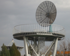
Iran’s space program is advancing expeditiously. It is mainly backed by the available potentials and scientific and technical expertise that is gained in course of the decades of work and enthusiasm. As one of the founding members of COPUOS in 1958, Iran joined the International Telecommunications Satellite Organization (Intelsat) thirty-eight years ago in 1970 and also involved in installation and use of the Standard A Station in Asad-abad, Hamedan. However, it was the launch of United States ERTS -which later became Landsat-1- in 1972 that indeed spurred real interest in remote sensing and space technologies in the country. Iran built a facility at Mahdasht, 65 kilometers west of Tehran, to obtain remote sensing imagery from the satellite. Mahdasht Satellite Receiving Station was considered as one of the major few sites around the world for data acquisition from Landsat. It is indeed a reality that establishment of the Mahdasht Satellite Receiving Station for Landsat data acquisition was the first cooperation program between USA and Iran on space technology. Almost all of the old employees of the Iranian Remote Sensing Center (IRSC), the majority of them are presently retired, remember the time when they were very happy and proud of working in a center which functions and activities was unique around the world and was limited to only few sites.
The IRSC operated the facility. It was established to collect, process, and distribute relevant imagery products to users throughout the country for resource planning and management. Over the years it supplied data to assist in identifying areas for development. It enabled scientists to identify areas prone to earthquakes, floods, landslides and other natural disasters and threats. The center was used to investigate greenhouse gas emissions and air pollution in the large urban areas, and to monitor wetlands, inland water basins and the environment of the Caspian Sea and the Persian Gulf.
In February 2004, the Iranian Space Agency (ISA) was established, with a mandate for all civilian applications of space science and technology. That was a long and practical step forward not only towards concentrating the country’s efforts in advancing relevant science and technology in effective use of outer space for peaceful purposes but also to enhance the cooperation at the international level for this very well deserved purpose. Since then the activities and functions of IRSC has been covered by the newly established ISA.
Promoting the applications of space science and technology for peaceful purposes is both a vital part of Iran’s current plan and very essential part of its strategy. This includes close attention to the important concepts such as public awareness, capacity building, research and exchange of experience simultaneous with the expansion of bilateral and multilateral cooperation in regional and global levels. In addition to Iran’s efforts towards such activities the need to expand national capabilities in application of technology is always felt. This expansion has been recognized in the country’s mid and long-term plans leading to emergence of Earth observation and satellite manufacturing industry in Iran. In light of continuous capacity building and development of expert human resources and scientists in recent few decades development of Omid, Sina-1, Mesbah, SMMS, Pars (Sina-2), Sepehr and ZS4 are the practical achievements for the country. Sina-1 is the only operational Iranian satellite in orbit that is the result of bilateral cooperation between Iran and the Russian Federation, while Omid is considered the country’s indigenous satellite planned to be launched in the near future.
In addition to space segment, Iran has been developing throughout the country its ground segments and facilities for communications and data acquisition since long ago. Boomhen, Asadabad and Isfahan are the ground stations established mainly for communication purposes while the old Mahdasht Ground Receiving Station which mission was receiving data from Landsat three decades earlier is being developed to become the Mahdasht Space Center in the future. Other ground stations have also been established for receiving remote sensing data managed and controlled by the private sector and universities.
“According to the Fourth Five-Year Development Plan of the country [2005-2010] US$422 million is allocated for space science and technology development,” says Muhammad Suleimani, the Minister of Communications and Information Technology. “Space science and technology could lead to facilitate and accelerate communications, saving expenses, time and increasing the efficiency, and forecasting and mitigating damages caused by disasters”, he adds, and continues, “Iranian government in its 10-year plan aims at providing the software and hardware and creating the infrastructure for attaining the capability and capacity in design, manufacturing, test, launch, operationalizing and control of the satellites. Increasing public awareness, training and education of expert human resources, research on new technologies, benefiting the domestic potentials and developing the international cooperation are the strategies of the plan in space domain”.
ISA since its establishment has given the highest priority to the international cooperation that is in continuation of the country’s policy for active international cooperation in space applications since few decades earlier. It has been used as a vehicle for Iran’s diplomatic engagement with the world community. ISA used its position on the UN’s Committee for the Peaceful Uses of Outer Space to contribute to the third UN International Conference on Exploration and Peaceful Uses of Outer Space (UNISPACE-III). Iranian officials have chaired an action team on the development of a worldwide comprehensive strategy for environmental monitoring and taken part in the development of the UN Space-based Platform for Disaster Management (SPIDER) locally. At a regional level, Iran actively cooperates with the UN Economic and Social Commission of Asia and the Pacific (ESCAP), and in particular with the Regional Program on Space Technology Applications (RESAP). Cooperative plan for the establishment of a Center for Informed Space-based Disaster Management and an affiliated research center have been advanced.
The country is a member of the Asia-Pacific Space Cooperation Organization (APSCO) under the initiative of the Multilateral Cooperation on Space Technology Applications in Asia and the Pacific (AP-MCSTA). It also provides funding for the organization, along with China, Indonesia, Pakistan, Thailand, Turkey, Bangladesh, Mongolia and Peru.
Investing in space is expensive. It can only be justified in Iran since all aspects of the country’s space program are integrated into the social, economic, educational, technical and political life of the nation. Stepping forward in this important way requires international cooperation and collaboration as the main requisite for the success of such the endeavor.
Leave a Comment »


Blog at WordPress.com.
Entries and comments feeds.

Leave a comment